|
PUBLISHER
|
YEAR
|
MAP TEXT
|
Bertelli (Ferrando)

Map of Cyprus
(728'455 bytes) |
1562 |
Ferrandus BERTELLI , " Isola di Cipro " - " Cyprus Insula olim Macharia... Romae M.D.LXII , Ferandus Bertelli excude " (182x250mm) , Rome 1562 . Loose sheet . Contemporary colour .
This very rare map of Cyprus was first issued in Rome in 1560 by a certain "B.F." The Venetian , F. Bertelli published the same map two years later , in 1562 , after it had been re-engraved by the Roman cartographer Marius Kartaro whose monogram , "M.K.", appears at the bottom right corner . It is a loose sheet map but it has also been traced in Lafreri type atlases (IATO collections) . The present copy was once in the famous Novacco Map Collection . Although published in the 1560s , when such Venetian cartographers like Camocio were at work (see Fig. 7) , this map is more akin to Bordone's woodcut style of the 1520s (see Fig. 2) and uses mostly pictorial signs rather than toponyms .
|
Xylander, Gulielmus

Map of Cyprus
(601'186 bytes) |
1571 |
Gulielmo XYLANDRO , "Cyprus" , woodcut (75x120mm) page 779 , Basle 1571
The small woodcut map originated in 1561 in Ioannis Honterus' Cosmographia published in Basle by Henricus Petri . A decade later Petri published G. Xylandro's edition of Srabo's geographical work and the same small map of Cyprus was republished along with five other woodcuts of Greek islands .
The map is wholly based on Ptolemy's map of the island . It is printed at the lower part of page 779 where the text on Cyprus begins set in two columns : Greek on one and Latin translation on the other . The contents of the map are ancient but the three main medieval towns of Nicosia , Famagusta and Limassol are also indicated .
|
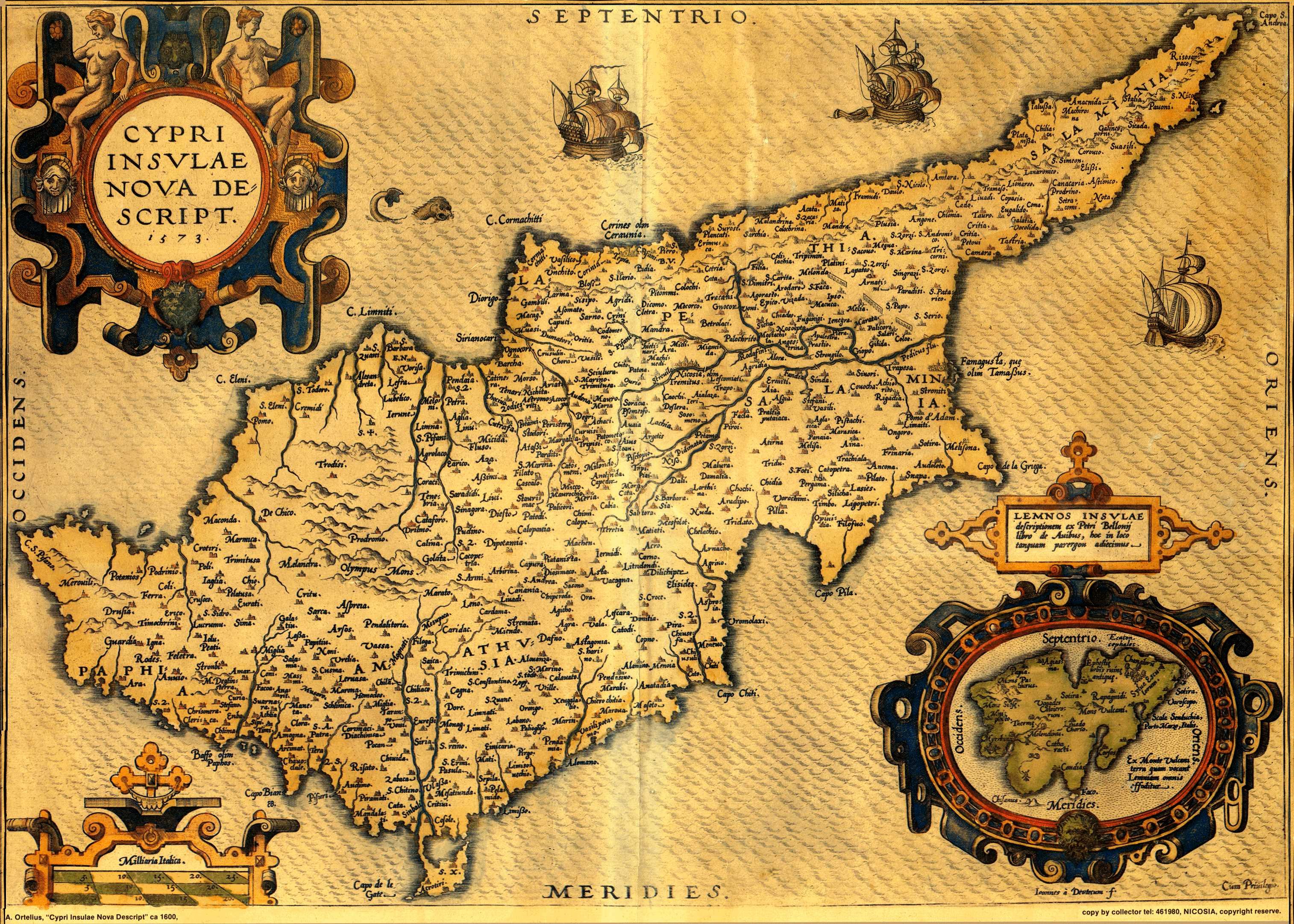
Ortelius, Abraham

Map of Cyprus
(728'455 bytes) |
1574 |
Abraham ORTELIUS (publisher) , Ioannes a DEUTECUM (engraver) , "Cypri Insulae Nova Descript . 1573 ." (350x495mm) page 52 , Theatrum Orbis Terrarum , Antwerp 1574 . Latin .
The first edition of Ortelius' Theatrum (Antwerp 1570) included an old-type map of the island (see Fig.88). In 1573 , in Additamentum I , Ortelius introduced a new map of Cyprus coupled with Lemnos inside a cartouche . His prototype was an extremely rare map of Cyprus by Jacomo Franco published in Venice in 1570 . Franco's map offered the latest correct data concerning Cyprus at that troubled period . Strangely , Franco did not make further use of his map . Thus , Ortelius' map of 1573 became the most advanced and correct prototype , destined to be used by cartographers and publishers throughout Europe until the middle of the 18th. century . The text at the back was periodically up-dated by Ortelius while his engravers conditioned the printing plate since the map was published in all the subsequent editions of the Theatrum in various languages .
|
Ortelius, Abraham

Map of Cyprus
(1'086'246 bytes) |
1584 |
Abraham ORTELIUS , "Insular . Aliquot Aegaei Maris Antiqua Descrip . "-"Cyprus Insula laeta choris ,..."(360x470mm) page 90 , Theatrum Orbis Terrarum , Antwerp 1584 . Latin . Coloured .
Drawn by Ortelius himself , this map is a reduced version of the map (Fig. 10) and shows Cyprus with nine insets of other Greek islands . It was first published by Ortelius in Additamentum III and as of 1584 it was included in the Parergon , a supplement to the Theatrum . The map contains ancient toponyms . The present edition comes from the original of 1584 (see also Fig. 11 of 1608 after the place name "Amathus" was added on Cyprus (1587) and "Melanthy Scopuli" deleted from the Greek islands (ca 1600).
|
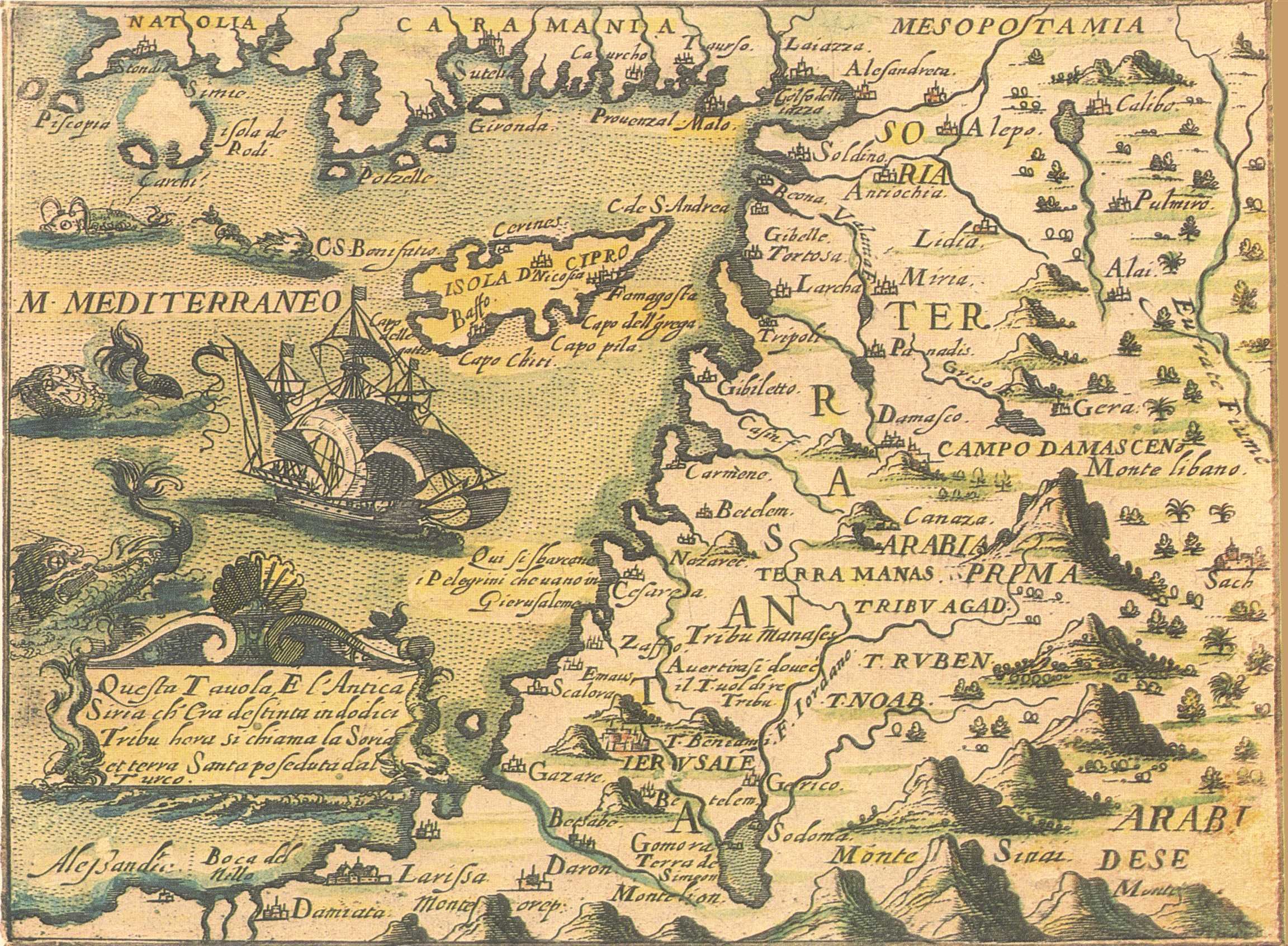
Rosaccio, Gioseppe and Franco, Giacomo

Map of Levant
(697'874 bytes) |
1598 |
Gioseppe ROSACCIO(author) , Jacomo FRANCO(engraver) ,"Isola D Cipro" - "Natolia..." (143x192mm) , Viaggio Da Venetia A Constantinopoli..., Venice 1598 or later . Coloured .
Map of the Levant , engraved by Jacomo Franco . Number"82" written in manuscript ink appears on top right corner . The same map is found among the 75 maps and plans in entry(18) , the Viaggio . It is not known from which edition of the Viaggio the present map comes . The Viaggio was first published in 1598 with Rosaccio's text but there were various other editions with , or without text , in the 17th. century .
|
Ortelius, Abraham

Map of Cyprus
(1'192'937 bytes) |
1600 |
Abraham ORTELIUS (publisher) , Ioannes a DEUTECUM (engraver) , "Cypri Insulae Nova Descript . 1573 ." (350x495mm) page 52 , Theatrum Orbis Terrarum , Antwerp 1600 . Latin . Coloured .
The first edition of Ortelius' Theatrum (Antwerp 1570) included an old-type map of the island (see Fig.88). In 1573 , in Additamentum I , Ortelius introduced a new map of Cyprus coupled with Lemnos inside a cartouche . His prototype was an extremely rare map of Cyprus by Jacomo Franco published in Venice in 1570 . Franco's map offered the latest correct data concerning Cyprus at that troubled period . Strangely , Franco did not make further use of his map . Thus , Ortelius' map of 1573 became the most advanced and correct prototype , destined to be used by cartographers and publishers throughout Europe until the middle of the 18th. century . The text at the back was periodically up-dated by Ortelius while his engravers conditioned the printing plate since the map was published in all the subsequent editions of the Theatrum in various languages . This map here is a 1600 copy.
|
Ortelius, Abraham

Map of Cyprus
(696'397 bytes) |
1608 |
Abraham ORTELIUS , "Insular . Aliquot Aegaei Maris Antiqua Descrip . "-"Cyprus Insula laeta choris ,..."(360x470mm) page 90 , Theatrum Orbis Terrarum , Antwerp 1608 . Italian . Original colouring .
Drawn by Ortelius himself , this map is a reduced version of the previous map (Fig. 10) and shows Cyprus with nine insets of other Greek islands . It was first published by Ortelius in Additamentum III and as of 1584 it was included in the Parergon , a supplement to the Theatrum . The map contains ancient toponyms . The present 1608 edition comes from the third known state of the engraved plate(see the original of 1584 , Fig. 89) , i.e. after the place name "Amathus" was added on Cyprus (1587) and "Melanthy Scopuli" deleted from the Greek islands (ca 1600) .
|
Mercator, Gerard

Map of Cyprus
(520'012 bytes) |
1610 |
Gerard MERCATOR , Jodocus HONDIUS , " Cyprus " (140x185mm) , Atlas Minor ..., Amsterdam 1610 . Latin . Coloured .
It was Jodocus Hondius who had introduced in 1606 a map of Cyprus in Gerard Mercator's , Atlas sive Cosmographicae Meditationes(see Fig. 95) . A reduced replica of that map with the insets of six Greek islands below , was included in Hondius' Atlas Minor in 1607 . Like so many other maps of Cyprus , as for example Magini's (Fig. 26) , it finds its prototype in Ortelius' Cyprus map of 1573 (Fig. 10) . The Atlas Minor was published in various languages and by different authors nearly 30 times with minor alterations . The present map comes from the 1610 Latin edition which is a variant of the first (1607) .
|
Hondius, Jodocus, I and Bertius, Petrus

Map of Cyprus
(453'939 bytes) |
1616 |
Jodocus HONDIUS , Petrus BERTIUS , " Cyprus " - "Descriptio Cypri" (92x132mm) page 698 , Tabularum Geographicarum , Amsterdam 1616 . Latin . Coloured .
With new maps, slightly larger than those of the Caert-Thresoor , Hondius began in 1616 a new series of pocket atlases , the Tabularum Geographicarum , using the Latin text Petrus Bertius had written in 1600 for the Caert-Thresoor . This map of Cyprus comes from the first Latin edition of 1616.
|
Janszoon, Willem and Blaeu, Willem Janzsoon

Map of Cyprus
(1'627'638 bytes) |
1647 |
Willem Janszoon and Joan BLAEU , " Cyprus Insula " (350x500mm) , Theatrum Orbis Terrarum , sive Novus Atlas , Amsterdam 1647 . Latin . Coloured .
A new double folio map of Cyprus completely based on the famous 1573 Cyprus map of Ortelius (Fig . 10) but with artistic alterations that render it the finest copper-plate map of the island until that time . It appeared first in the second volume of Willem Blaeu's opus , Atlas Novus published in 1635 in Latin , German , Dutch and French . The same map was used by Joan Blaeu , the son of Willem , in eleven-volume , Atlas Maior , Sive Cosmographia Blaviana . In 1637 , two years after its original publication , Joannes Janssonius made a replica of the map which appeared in the Janssonius-Hondius , Appendix Atlantis (Amsterdam 1637) . The two copper-plates are hardly distinguishable but for some minor differences such as Nicosia corrupted to Nocosia on Janssonius' map .
|
Merian, Matthaeus

Map of Cyprus
(1'398'338 bytes) |
1649 |
Joan L GOTOFRED (author) , Matthaeus MERIAN the Elder (engraver-publisher) , "Cyprus Insula" (305x375mm) , Archontologia Cosmica , Frankfurt 1649 .
Merian's map of Cyprus is a reduced version of Blaeu's map (Fig . 37) with all the decorative motifs , including the figure of Aphrodite drawn by her swans at the lower right corner . It was first published in the second edition of Gotofred's three-volume travel book , Archontologia Cosmica . Although this map of Cyprus is of no cartographical significance the same edition includes a very important plan of Famagusta (Fig. 42) .
|
Cluverius, Philip

Map of Cyprus
(333'504 bytes) |
1661 |
Philip CLUVER , Introductionis in Universam Geographiam...,Amsterdam 1661 & Johann Christoph BECMANN , Historia Orbis Terrarum , Geographica , Frankfurt & Leipzig 1707 . 4to (203x165mm) . Latin .
Two distinct books bound together ; both deal with the history and geography of the world and were basic geography texts with wide circulation . Culver's Introductionis in Universam Geographiam includes a map of Cyprus . The book is a small Atlas of the world with 46 maps , one of each main country . It was first published in 1624 without maps and because it was well received it went through many issues in the 17th. And 18th. centuries . However , not all Cluverius' editions contain a map of Cyprus , and those that do , show four different versions . The present edition contains the third version of the map ( Fig. 44 of 1661 above) and it is of particular importance because it was published by Joannes Janssonius . The map of Cyprus is by the famous Dutch engraver Petrus Kaerius . Cyprus is the 42nd map in the "Index Tabularum". It is a double-page map , preceding page 127 at the end of Liber V where the text on Cyprus begins (pp 127-128). The title reads "Cyprus Ex deliniatione Ubonis Emmii" (130x195mm) . Emmius was a cartographer , who worked for Hondius and Janssonius . The map is based on the Parergon (1584) map of Ortelius (Fig. 11) but its shape is rather deformed and it has fewer ancient contents .
|
Mallet, Alain Manesson

Map of Cyprus
(202'062 bytes) |
1683 |
Alain Manesson MALLET , "Isles de Cypre" (140x98mm) page 297, Description de l' Univers , Paris 1683 . French . Coloured .
This map , not recorded in the Stylianou book , The History of the Cartography of Cyprus , is included in the Description de l' Univers first published in French by D. Thierry in Paris in 1683 . The author , Mallet , was an engineer , and the book which was in five volumes contained maps , plans and city views . In the first edition , the map of Cyprus has a page number (297 in the top right corner) and text on verso . This map comes from the original plate . (see also Fig. 62 of the 1719 German edition for differences of the two plates) .
|
Peeters, Jacques

Map of Cyprus
(778'574 bytes) |
1685 |
Jacques PEETERS , " Cipre "-" Cyprus Insula " (137x206mm) , Description de principales villes , Antwerp after 1685 .
Peeters was an engraver and a publisher . His Description des principales villes... contained 143 copper engravings of Greek cities , harbours and islands . The amazing characteristic of his map of Cyprus is that it ignored all the valid prototypes of Cypriote cartography and chose to copy the deformed map of Cyprus which Beauvau published at the beginning of the 17th. century (Fig. 32) . His signature , "J. Peeters excudit", appears at the end of a list of place names that correspond to arabic numbers on the map , a feature also taken from Beauvau's map . Peeters added a cartouche , sailing ships , Aphrodite drawn by swans and other decorative features around the map .
|
Dapper, Olfert (Olivier)

Map of Cyprus
(898'682 bytes) |
1703 |
Olfert (Olivier) DAPPER , Description Exacte Des Isles De L' Archipel , Amsterdam 1703 . Folio (360x270mm) . French .
A folio book originally published in Dutch as Naukeurige Beschryving der Eilanden in de Archipel der Middelantsche Zee...(Amsterdam 1688) . The present , French edition was published by George Gallet in Amsterdam . Dapper's book is a magnificent production as far as printing is concerned and at the same time an interesting source for the islands of the Archipelago . Dapper never visited the places he described in his book . He compiled his descriptions from the writings of known travellers , or from the accounts of seamen . The text on Cyprus ("De l'Ile de Cypre") on pages 21-88 , is preceded by a double-page map of the island entitled "Cyprus Insula" (287x374mm) (the one above) . The author of the map remains unknown but his prototype was Blaeu or Janssonius (Fig. 37) Dapper's map is basically distinguished from its prototype because of a new marine composition at the lower right corner that replaces Blaeu's Aphrodite and swans of Fig. 37 .The extensive text is illustrated with two other Cyprus items . The first is a town plan of "Famagouste" (125x160mm) (see Fig.49) on page 30 which accompanies the relevant account entitled "De la ville de Famagouste" (pp 29-31) . It is a conventional , three-dimensional view which does not include the numerous churches of the town (Fig. 49) . Nevertheless , it is an important plan for the study of the town's fortification system , as it resembles a wooden model at the Museo Storico Navale in Venice which is labelled "Fortezza di Famagosta" and dated 1571 (see also Fig. 56) . The last Cyprus item is a double-page engraved illustration of the Larnaca harbour seen from the sea and depicting the fort and the church of St. Lazarus . It is entitled "Salinas of Soutpannen anders Arnica di Salinas ou les Salines" (280x343mm) and it precedes the relevant account , "De la ville d' Arnica ou D' Arnacho" on pages 33-35 .
|
Dapper, Olfert (Olivier)

Map of Famagusta
(1'215'579 bytes) |
1703 |
Olfert (Olivier) DAPPER , Description Exacte Des Isles De L' Archipel , Amsterdam 1703 . Folio (360x270mm) . French .
A folio book originally published in Dutch as Naukeurige Beschryving der Eilanden in de Archipel der Middelantsche Zee...(Amsterdam 1688) . The present , French edition was published by George Gallet in Amsterdam . Dapper's book is a magnificent production as far as printing is concerned and at the same time an interesting source for the islands of the Archipelago . Dapper never visited the places he described in his book . He compiled his descriptions from the writings of known travellers , or from the accounts of seamen . The text on Cyprus ("De l'Ile de Cypre") on pages 21-88 , is preceded by a double-page map of the island entitled "Cyprus Insula" (287x374mm) (Fig. 48). The author of the map remains unknown but his prototype was Blaeu or Janssonius (Fig. 37) Dapper's map is basically distinguished from its prototype because of a new marine composition at the lower right corner that replaces Blaeu's Aphrodite and swans of Fig. 37 .The extensive text is illustrated with two other Cyprus items . The first is a town plan of "Famagouste" (125x160mm) (the one above) on page 30 which accompanies the relevant account entitled "De la ville de Famagouste" (pp 29-31) . It is a conventional , three-dimensional view which does not include the numerous churches of the town . Nevertheless , it is an important plan for the study of the town's fortification system , as it resembles a wooden model at the Museo Storico Navale in Venice which is labelled "Fortezza di Famagosta" and dated 1571 (see also Fig. 56) . The last Cyprus item is a double-page engraved illustration of the Larnaca harbour seen from the sea and depicting the fort and the church of St. Lazarus . It is entitled "Salinas of Soutpannen anders Arnica di Salinas ou les Salines" (280x343mm) and it precedes the relevant account , "De la ville d' Arnica ou D' Arnacho" on pages 33-35 .
|
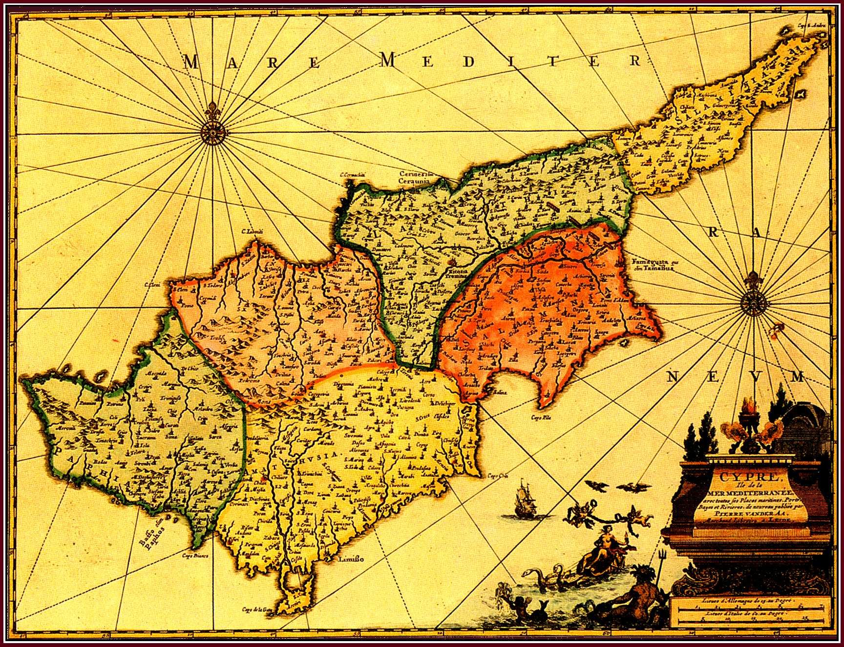
Valk, Gerard and Schenk, Pieter

Map of Cyprus
(866'915 bytes) |
1705 |
Gerard VALK et Petrus SCHENK , "Cyprus Insula" (380x500mm) , Amsterdam ca 1705 . Coloured .
Janssonius was not the only cartographer guilty of copying maps by great cartographical publishers , like Blaeu . The cartographical house of Valk and Schenk , having obtained after 1676 copper-plates from Joannes Janssonius' heirs , worked the Cyprus plate . This had been made by Janssonius in 1637 when he copied Blaeu's original (Fig. 37) of 1635 . In this manner Nocosia seems to have been corrected to Nicosia but it is still uncertain when the map was first published by Valk and Schenk in this second , amended state . In any case , it is found in a collection of maps published ca 1705 in Amsterdam . It is a handsome map to look at , but of no cartographical importance .
|
Lasor A Varea (Savonarola), Alfonsus

Map of Cyprus
(811'586 bytes) |
1713 |
Alfonsus LASOR A VAREA (SAVONAROLA) , "Isola di Cipro , Fellice Brunelo , V.F." (212x157mm) , Universus Terrarum Orbis , Patavia 1713 . Latin .
The case of Lasor , pseudonym of Innocenzo Rafaele Savonarola , is a fine example that illustrates the reuse of old plates of the end of the 16th. century in books of the 18th. century . There are various items concerning Cyprus in Lasor's book , Universus Terrarum Orbis. In volume I there is a map of Cyprus first published in Venice ca 1590 in Raccolta de Disegni...da Venetia a Constantinopoli (same map as in the Viaggio , entry 18 fig. 21) ; and also the present map of Cyprus which , though slightly reworked , is the map engraved by Natale Bonifacio whose monogram , "N.B.F." occurs at the bottom left corner . This map was originally published by Fellice Brunelo ca 1590 in Venice . It was subsequently used in various isolaria at the end of the 16th. century and here it is being employed by Lasor with page legend "T.I. pag. 315" engraved in the upper left corner of the map surface .(This is the same map as Fig . 109 of the present collection with the difference that it is a little larger and not coloured) .
|
Lasor A Varea (Savonarola), Alfonsus

Map of Nicosia
(1'080'801 bytes) |
1713 |
Alfonsus LASOR A VAREA (SAVONAROLA) ,Francesco VALEGIO , "Nicosia" - "In Insula Cipri..."(87x132mm) page 258 ,Universus Terrarum Orbis... , Patavia 1713 . Latin .
Another Cyprus item in the second volume of Lasor's book is this conventional plan of Nicosia with the Venetian walls . This plan was first published ca 1579 in Venice in the towns-book , Raccolta di le piu illustri et famose citta di tutto il mondo , by Francesco Valegio . Valegio's plan is based on a siege-plan of Nicosia published by Gamocio ca 1570 , but it eliminates all the pictorial elements concerning the siege and replaces the Turkish forces around the walls with cultivated land .
|
Lasor A Varea (Savonarola), Alfonsus

Map of Famagusta
(921'264 bytes) |
1713 |
Alfonsus LASOR A VAREA (SAVONAROLA) , "Famagosta" (100x178mm) page 370 ,Universus Terrarum Orbis... , Patavia 1713 . Latin .
Like the map of Cyprus (Fig. 59) , this plan of Famagusta from the first volume of Lasor's book , originated in Raccolta de Disegni...da Venetia a Costantinopoli , a booklet published in Venice ca 1590 . This is the very same siege-plan of "Famagosta" engraved by Gioseppe Rosaccio in the late 16th. Century and encountered in the Viaggio which was published in 1598 by Jacomo Franco (see entry of Fig. 22) .
|
Lasor A Varea (Savonarola), Alfonsus

Map of Cyprus
(701'604 bytes) |
1713 |
Alfonsus LASOR A VAREA (SAVONAROLA) , "Isola di Cipro , Fellice Brunelo , V.F." (205x152mm) , Universus Terrarum Orbis , Patavia 1713 . Latin . Coloured .
The case of Lasor , pseudonym of Innocenzo Rafaele Savonarola , is a fine example that illustrates the reuse of old plates of the end of the 16th. century in books of the 18th. century . There are various items concerning Cyprus in Lasor's book , Universus Terrarum Orbis. In volume I there is a map of Cyprus first published in Venice ca 1590 in Raccolta de Disegni...da Venetia a Constantinopoli (same map as in the Viaggio , entry 18 fig. 21) ; and also the present map of Cyprus which , though slightly reworked , is the map engraved by Natale Bonifacio whose monogram , "N.B.F." occurs at the bottom left corner . This map was originally published by Fellice Brunelo ca 1590 in Venice . It was subsequently used in various isolaria at the end of the 16th. century and here it is being employed by Lasor with page legend "T.I. pag. 315" engraved in the upper left corner of the map surface .(This is the same map as Fig . 59 of the present collection with the difference that it is a little smaller and coloured) .
|
Mallet, Alain Manesson

Map of Cyprus
(513'681 bytes) |
1719 |
Alain Manesson MALLET , "Die Insel Cypern" - "Fig. CXXXII" (139x98mm) , Description de l' Univers , Frankfurt 1719 . German . Coloured .
This map , not recorded in the Stylianou book , The History of the Cartography of Cyprus , is included in the Description de l' Univers first published in French by D. Thierry in Paris in 1683 . The author , Mallet , was an engineer , and the book which was in five volumes contained maps , plans and city views . In the first edition , the map of Cyprus has a page number (297) and text on verso . The present map comes from the German edition of 1719 entitled Beschreibung des ganzen Welt-Kreisses published by J.A. Jung . The maps of the German edition are copied on new plates from those of the French edition (see Fig. 62Haj) but have no text on verso . A figure number is written after the German title , "Die Insel Cypern", on the top right margin outside the borders of the map .
|
Aa, Pierre vander

Map of Cyprus
(495'799 bytes) |
1730 |
Pierre (Pieter) van der AA . "Cypre Ile de la Mer Mediterranee ..." (286x376mm) , Nouvel Atlas , Leiden 1714 or 1730 . Coloured .
This map by van der Aa copies the Cyprus map of Blaeu (Fig. 37) . It is smaller in size and Blaeu's exquisite decorative treatment has been replaced by a cartouche and new pictorial motifs . The map was first published by van der Aa in his Nouvel Atlas (1714) which ca 1730 was re-issued in Amsterdam . Finally , ca 1729/30 the map was included in the very rare multi-volume atlas of van der Aa , La Galerie Agreable du Monde (Leiden) .
|
Roux, Joseph

Map of Levant
(1'255'317 bytes) |
1764 |
Joseph ROUX , "I. De Cypre" - "X. Feuille" (813x555mm) , Carte de la Mer Mediterranee en douze feuilles..., Marseille 1764 . Coloured .
This sea-chart is the tenth of twelve maps in J. Roux's Carte de la Mer Mediterranee from which he extracted and published in the same year(Marseille 1764) his Recueil of the main ports around the Mediterranean (Fig. 68) . The chart shows not only Cyprus , but also the coastlines around the Eastern Mediterranean . The map of Cyprus does not follow any of the established cartographical renderings of the island . This indicates how completely different the line of development was as far as sea-charts were concerned , since they were made by sailors for navigation purposes . For the same reason , most of the contents are on the south coast where navigation was more frequent and the place names are heavily corrupted since they are written the way they were pronounced by sea-men . After ca 1779 another plate was made for this map , but the present copy is from the original plate .
|
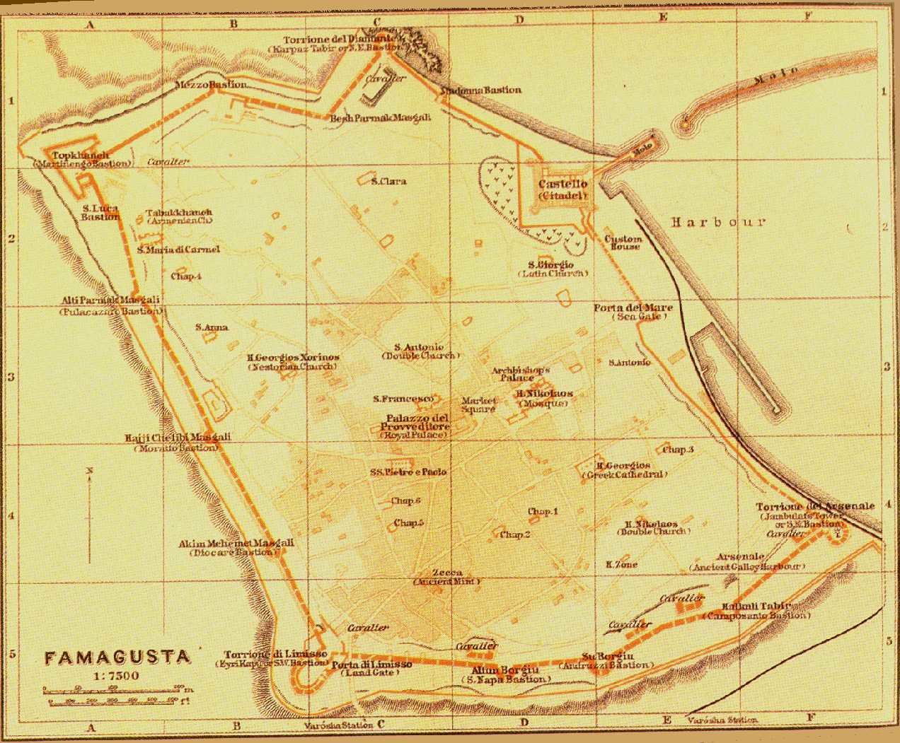
Baedeker, Karl
Map of Famagusta
(185'592 bytes) |
1914 |
Karl BAEDEKER , Konstantinopel , Balkanstaaten , Kleinasien , Archipel , Cypern , Leipzig 1914 . 8vo (161x107mm) . German .
This travel guide by the famous firm of Baedeker , the pioneers in the field of guide-books , includes 18 maps , 50 plans and 15 panoramas . It is a second edition in German and quite important as far as Cyprus is concerned . It includes three folding items on Cyprus : one map of "Cyprus" (146x240mm) , a plan of the old town of "Famagusta" (146x179mm) and a plan of "Nicosia" (144x148mm) within the walls . All three are coloured and signed by "Wagner & Debes' Geogr . Establ ." Of particular importance is the plan of Nicosia , the capital of Cyprus , because it gives valuable information as to its growth and development in the first decades of British rule .
|
Baedeker, Karl

Map of Nicosia
(270'174 bytes) |
1914 |
Karl BAEDEKER , Konstantinopel , Balkanstaaten , Kleinasien , Archipel , Cypern , Leipzig 1914 . 8vo (161x107mm) . German .
This travel guide by the famous firm of Baedeker , the pioneers in the field of guide-books , includes 18 maps , 50 plans and 15 panoramas . It is a second edition in German and quite important as far as Cyprus is concerned . It includes three folding items on Cyprus : one map of "Cyprus" (146x240mm) , a plan of the old town of "Famagusta" (146x179mm) and a plan of "Nicosia" (144x148mm) within the walls . All three are coloured and signed by "Wagner & Debes' Geogr . Establ ." Of particular importance is the plan of Nicosia , the capital of Cyprus , because it gives valuable information as to its growth and development in the first decades of British rule .
|


 Lawyer-jurist
 Company
 Proxy
Proxy Insurance
 Apostil
 Rent
Rent Bicycle